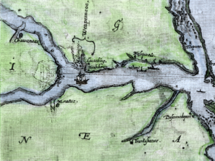
The Virginea Pars map, drawn by John White in the 1580s
For more than 400 years, a mystery has puzzled American and English historians alike—what happened to the English colonists of Roanoke Island? Did they leave to find a more hospitable site? Were they killed by the native people? Did they starve to death?
Roanoke Colony was established by Sir Walter Raleigh on an island on the coast of present-day North Carolina. After several previous expeditions to the region, a supply ship reached the site in 1590. War between England and Spain had delayed communication with the Roanoke colonists for three years. The ship’s crew found no trace of the colony’s 90 men, 17 women, and 11 children. Nor were there any signs of violence or calamity. The only clues were the word “Croatoan” carved into a post and “Cro” carved into a tree trunk. These notes must have referred to the Croatans, a local Native American tribe.
Researchers examining an old map in the British Museum think they have found a clue to the colonists’ disappearance. The so-called Virginea Pars map was made between 1585 and 1586 by John White, an artist, mapmaker, and friend of Raleigh’s. The map has a patch over a symbol that appears to be a fort visible only when the map is placed over a light. Could the colonists have headed toward this location with the intention of founding a new colony? The scholars think it is a good possibility.
Why, though, had the map been treated in this way? After all, Raleigh needed the map to show potential investors in future settlements. It would have been essential, too, for colonists who needed to maneuver their boats in the coastal waters. One possibility is that White hid the fort location to keep the information falling into the wrong hands—namely, Queen Elizabeth I’s enemies. So, perhaps historians have solved one mystery only to create a new one.
Image credit: © North Wind Picture Archives via AP Images
Related Links
- Roanoke Island: The Lost Colony
This site provides the basic history of the Roanoke Colony.
(Source: University of North Carolina; accessed May 31, 2012) - Roanoke Colony
Read details about Roanoke Colony, along with theories about the colonists’ disappearance.
(Source: Wikipedia; accessed May 31, 2012) - Drawn in Invisible Ink, Is This the Site of Walter Raleigh’s Lost Colony?
Get a good look at the map and learn more about how 16th-century intrigue played a part in the story.
(Source: The Independent, May 3, 2012) - What Happened to the Lost Colony?
Review the many theories about the fate of the Roanoke colonists.
(Source: North Carolina Department of Cultural Resources; accessed August 7, 2013) - Hidden Inks, Paper Patches—Cartographic Secrecy, 1500s Style
This site has links to other related articles.
(Source: InCartoBlog; accessed May 31, 2012) - Time Team America: Fort Raleigh, North Carolina
Watch a video about excavations in the Roanoke region.
(Source: PBS; accessed May 31, 2012)


interesting that we discovered somthing then created another this is a mysterery that i personally think wont ever be solved
;P
🙂 🙂 🙂 🙂 :0 🙂 ;( 🙂
🙁
🙂
wow
i was there
Im glad some one found thy colonists map. Thee friends
will finally rest in peace.
i think its weird that the colonists went through all the effort and then just….DIED 🙂
i read it !!1!!!!!! lololololollolololol
i liked it
I want to solve this mystery of the case
wow
you hit
Nice article
Approved.
this story only makes me want to figure out this mystery
this was interesting
like to learn about it
p
So…in what modern day county and or city was the fort located?