


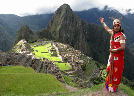
A Peruvian man in ancient Incan dress stands before the Andean citadel of Machu Picchu.
Northwest of Cuzco, Peru, the Capac Ñan (Great Road) winds down from the lofty heights of Machu Picchu (seen above) to the Cajamarca Valley. The grander of the two engineering achievements is not the well-known Andean fortress, but the pedestrian path. In fact, the road was once the largest construction in the Western Hemisphere. In the Americas before the arrival of Europeans, this literal high way stretched roughly 3,700 miles along the Andes Mountains, from what is now Colombia to Chile.
The creation of the people we call the Inca, whose empire was known locally as Tawantinsuyu, the road was “built without iron tools, draft animals, a single arch, or the wheel.” Yet it includes suspension bridges and surveyor-straight sections that cut through the mountainous terrain. What is more, huge stretches of the cobblestone road still exist and are passable, centuries since they were built. In some places, it is three yards wide and walled with stones on both sides; in other places, the road is flanked by canals. One scholar compared the Inca road network to “the skeleton of a fish”—its “spine” running north–south with many east–west roads branching off.
The Inca used the road system to move their army over long distances, to send imperial messengers between the capital and Quito to the north, and for trade. Inca goods—feathers and wildlife, gold and silver, massive stones, and beach sand—moved along the Capac Ñan network. When the Inca road was designated as a UNESCO World Heritage Site in 2014, 273 distinct sites spread over nearly 4,000 miles were recognized. These features highlight its social, political, architectural, and engineering aspects. Now, the Smithsonian National Museum of the American Indian in Washington, D.C., is featuring an exhibit on “The Great Inka Road.”
Image credit: © Aurelio ALEJO/AFP/Getty Images
Related Links
- The Great Inka Road: Engineering an Empire
Explore the Smithsonian’s virtual exhibition of the amazing accomplishments and artifacts of the ancient Inca—based on ethnography and oral history interviews with indigenous people.
(Source: Smithsonian Institution National Museum of the American Indian; accessed August 10, 2015) - What It’s Like to Travel the Inca Road Today
Explore the remarkable ruins of the ancient Inca’s road through the Andes.
(Source: Smithsonian Magazine, July 2015) - Qhapaq Ñan, Andean Road System
This website describes the Inca Road as a UNESCO World Heritage Site; includes a Google-Earth map of the sites across six Andean countries.
(Source: UNESCO.org; accessed August 10, 2015) - How the Inca Empire Engineered a Road across Some of the World’s Most Extreme Terrain
Learn from travelers about the engineering feats of the ancient Inca.
(Source: Smithsonian Journeys Travel Quarterly, June 26, 2015)
