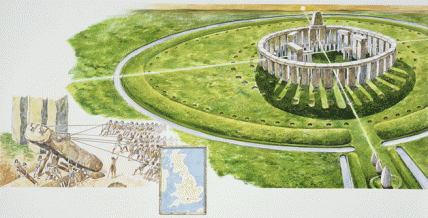
Artist’s reconstruction of complete-circle Stonehenge
The ancient monument known as Stonehenge, located in an expanse of the Salisbury Plain in the English countryside near the River Avon, has been called “probably the most studied landscape in the world.” For all the attention it has garnered, though, Stonehenge still presents more questions than answers—even as new breakthroughs in archaeological understanding of the massive stones have been announced.
Researchers with the Hidden Landscapes Project, a collaboration involving a British team and the Ludwig Boltzmann Institute, have found evidence of more than 15 formerly unknown or unrecognized Neolithic monuments—henges, barrows, pits, and ditches—below ground in Stonehenge’s surroundings. The new finds were detected by magnetometers and ground-penetrating radars, which resemble high tech lawnmowers. A magnetometer can sense underground structures by mapping variations in Earth’s magnetic field; with GPS guidance, geophysicists can pinpoint evidence of ancient buildings with amazing precision. And newly developed software enables the processing of the masses of raw data that these instruments generate, allowing almost real-time display of the information.
In July of last year, however, it was the careful eye of a groundskeeper at the World Heritage Site that noticed some grassy areas near the main circle were not growing as well as other areas during a particularly hot, dry stretch of weather. Observation of these “parch marks” led to the confirmation that the spots were places where gigantic stones had once been located—something that had even the geophysicists had missed.
Image credit: © DEA PICTURE LIBRARY/De Agostini/Getty Images
Related Links
- What Lies Beneath Stonehenge?
This article details the recent findings and ongoing work of the Hidden Landscapes Project at Stonehenge.
(Source: Smithsonian Magazine, September 2014) - The “Stonehenge Hidden Landscape Project”
Learn more about the cutting-edge geophysical and remote sensing tools being used to examine the landscape surrounding Stonehenge.
(Source: Ludwig Boltzmann Institute; accessed September 3, 2014) - Stonehenge “Complete Circle” Evidence Found
This article recounts how the nonspecialist’s eye helped support the “complete circle” theory of Stonehenge.
(Source: BBC News, August 30, 2014) - Stonehenge, Avebury and Associated Sites
This is the official UNESCO World Heritage website for Stonehenge and related nearby sites; includes photos, videos, descriptions, and a cool series of Google Earth zoom shots.
(Source: UNESCO; accessed September 3, 2014)


sweet
Interesting
cool
yea yea. sooooo cool
What the smerrrr?
Seems legit….
I don’t CAAAAAAAAAARE
Don’t you have a test about this
Lol
Very interesting!
cool
Awesome
thats so awesome and ive been to stonehenge as a a matter of fact peace out haters!
Lets make a story
cool so far
oooooooooooooooooooooo
HI
Hi
Hi
That is really awesome
will you be my best friend?
cool
Man is that cool
yo this stuff is real cool yall. respect this stuff someone a really long time ago planned this.